Hinton Road to Poplar Walk
Once a rural footpath, “Poplar Walk” survives today in the names of a street and alleyway that follow its long-established route into Loughborough Junction from the south, running down from the top of Herne Hill. At some point the northernmost stretch of this path became Hinton Road. This page looks at the area where this route approaches the central part of Loughborough Junction.
From the 1860s, this area at the foot of the high ground leading up to Herne Hill became the start point of a long section of railway viaduct that runs continuously all the way to the river Thames and Blackfriars, across the almost entirely flat land that exists between here and central London. This viaduct takes off from the end of an embankment that carries the railway from Herne Hill station.
In the years after the initial construction of the railway, sidings were built alongside the stretch of line between Herne Hill and Loughborough Junction. Over time these became a large and important complex used for sorting goods coming into London, known as Herne Hill Sorting Sidings. The longest of these reached right to the Loughborough Junction end of the embankment.
Immediately to the west of the railway embankment is what is now Shakespeare Road, not much more than a footpath until the road itself was constructed in the 1870s. Immediately to the east is what is now Hinton Rd and Milkwood Road. When the railway line appeared it created a division between these two areas of land, one accessed by Shakespeare Road and one by Hinton Road, a division that still exists today: it is not currently possible to get between Milkwood Road and Shakespeare Road without going via Coldharbour Lane or all the way up to Herne Hill station. To some extent the two sides of the railway line developed semi-independently of each other, with no established route directly between them.
Click on the 3d images below to enlarge them. Click the left and right arrows to see changes through time, or to see different parts of the model highlighted.


More detail
Early records of Poplar Walk
Poplar walk appears to be the route of a very long established footpath, which is visible on one of the earliest available maps with sufficient detail to show such features – the Rocque map of 1746. Maps from the 1840s and 1850s label it simply as “foot path”, and an 1862 map names it as “Poplar Walk”. This same map is one of the first to show the newly-built railway line, and it shows a portion of what is now Hinton Rd passing under the railway line. This “stub” of full width roadway is also visible on 1840s maps, so it predated the development of the railways.

Extract from John Rocque’s map of London published in 1846. The red arrow indicates what seems to be a footpath along the route of Poplar Walk. “Camberwel Lane” is an earlier name for Coldharbour Lane, and the footpath meets it opposite the end of what is now Loughborough Road. A good quality scan of this map can be found on the Yale University Library website.

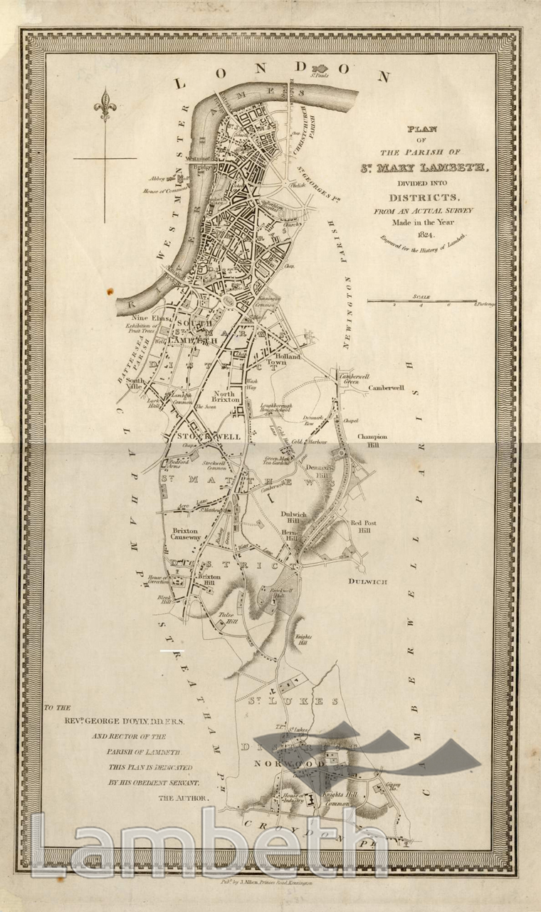
Extract from “Parish Map of St Mary’s Lambeth, 1824”, available on Lambeth Landmark. The red arrow indicates the route of Poplar Walk.

An extract from “Stanford’s Library Map of London and its suburbs, 1862”, available to view here on the Mappalondon site. The red arrow indicates Poplar walk.
Market Gardens and Nurseries
Note on the 1862 map above, that an area of land in between Poplar Walk and the railway line is marked as “Market Gardens”. These were areas of intensive fruit and vegetable cultivation commonly seen around the outskirts of London in the early 19th century. The Ianvisits website provides some history here. On the Ordnance Survey map of only about ten years later, these are no longer marked, the land having perhaps already been earmarked for development. However, a “nursery” is shown on the site between the two railway viaducts, including several greenhouses (identified by the cross-hatching on the map). Between the 1860s and the 1890s Loughborough Junction saw a rapid transition from a largely rural area to an urban one. The maps show that at the beginning of this transition period, it was still a place where fruit, vegetables and other plants were grown.

A ‘nursery’ with greenhouses shown on an 1870s Ordnance Survey map, on the site later occupied by the South London Granaries, now the ‘Coldharbour Works’ building.
The South London Granaries
In 1887 a large complex of buildings appeared on the site of what was previously the plant nursery. Most of this remains today and is now known as “Coldharbour Works”. Until recently it was known as the Shakespeare Business Centre. Of Loughborough Junction’s 19th century industrial buildings, these are really the only large scale ones that have survived – other large industrial buildings once existed within the area covered by the “Loughborough Junction’s central block” page but were demolished in the decades following WW2.
The 1903 Goad insurance map labels it as “Osbourne and Young South London Granaries” and indicates that the buildings contained grain warehouses, a flour warehouse, and various stables with hay and straw storage. Osbourne & Young appears to have later become Brinkler, Osbourne and Young, bird seed suppliers, and the initials B.O.Y. were recently revealed on one of the building’s old shopfronts – some further information is on LJAG’s website here.

The South London Granaries site as it appears on the 1903 Goad Insurance map. Coldharbour Lane is to the left.

The granary buildings as they appeared in 1963. Their appearance is not greatly altered today. Photo from Lambeth Landmark
It’s tempting to wonder whether the granary complex was served by the railway sidings at some point, but there does not seem to be any evidence that it was. Although a railway siding originally extended to a point directly next to the site, it was at an upper level, on top of the embankment, with no obvious means of transferring goods. In any case, this siding seems to have been curtailed in the 1870s when Shakespeare Road was laid out, and part of the railway embankment was cut away to accommodate the corner at the beginning of the road. This was before the granary buildings were constructed.
The Bill Posters’ yard
Note that on the Goad insurance map extract above, just to the right, or north-east, of the granary site, there is a yard marked “Bill Posters”, where it would appear that posters and other printed items were produced. The “rubber works” must have been related to the printing process. In photos of the area from the early 1900s, many promotional posters can be seen attached to walls, bridge piers and so on.
In more recent years, this area, which fills the space between the upper and lower railway lines, Hinton Road and the old granary buildings, has been used as a motor mechanics premises, and car wash site.

An extract from an early 1900s postcard. This view is looking south along Hinton Rd. Note the promotional posters and adverts pasted on the right-hand pier of the high level rail bridge. Perhaps some of these would have been printed at the ‘Bill Posters’ works which were located in the yard just beyond that bridge pier, on the right hand side.
The coal yard
The area of land along the south side of the embankment for the railway line towards Herne Hill is labelled as ‘market gardens” on 1860s maps – as discussed above. By the late 1870s, a site here is marked on a street renumbering plan as “coal yard” and this is visible on the Ordnance Survey map surveyed in the 1890s. It seems to have been in use until at least the 1950s. As with the granary site, it’s tempting to speculate that it was serviced by the railway sidings adjacent, but again there is no evidence this was the case. Maps do show a coal yard serviced by this complex of sidings but it was located at the Herne Hill end, and accessed from Shakespeare Rd on the north side of the embankment.

On this photo from 1968, looking north along Hinton Rd, the buildings at the entrance to the coal yard can just be seen on the left, a little beyond the “Green Shield” sign. They appear to have been small timber structures and look to be the same buildings that are seen in photos from the early 1900s. Photo is available on Lambeth Landmark here.

The coal yard site (indicated by the red arrow) as it appears on an 1890s Ordnance Survey map.
In around 2006-2007 the former coal yard site was redeveloped as the “Tram Close” housing development. The naming of this is a little misleading, as it suggests that the site had something to do with trams, but the only connection seems to be that the tram lines running along Hinton and Milkwood roads (also shown in the Ordnance Survey map) would have passed nearby.
Herne Hill Sorting Sidings

The extent of the sorting sidings can be seen in this 1890s Ordnance Survey map. Loughborough Junction station is just off the top of the map, and Herne Hill station just off the bottom.
The Herne Hill Sorting Sidings were an extensive complex of railway sidings stretching along both sides of the railway line between Loughborough Junction and Herne Hill. They performed an important role in marshalling freight trains moving goods into and out of central London. Their northern extent reached right up to the end of the embankment which ends just south of Hinton Rd. But as discussed in relation to the granary and coal yard sites, it does not appear that there was a direct interaction between these sidings and their immediate surroundings in the Loughborough Junction area.
There is a good summary of the history of the sidings in a history of the Milkwood Estate, published by the Herne Hill society, which can be found here.
The Hinton Road railway bridges
A double layer of rail bridges crosses Hinton Road – first to be built was the lower one which carries the line between Loughborough Junction and Herne Hill, and soon after came the higher one that carries the line between Denmark Hill and Brixton. Because both railway lines need to cross Hinton Road at nearly the same location, and at diagonal angles, the upper bridge has to deal with some awkward geometry and spans of varying lengths which on one side can cross the lower line and road separately, but on the other side need to cross both in one go. Further adding to the complexity is the fact that the lower railway viaduct was originally built as two tracks wide and later widened to four tracks. Figuring out exactly how these bridges evolved over time therefore involves a bit of speculation, and what is shown in the 3d model is a best guess based on looking at a large number of maps and photos.

The railway bridges over Hinton Rd, depicted (top left to bottom right) in 1862, 1865, 1866 and 2020
It’s likely that when the LBSCR built the upper bridge, they would have been aware of the LCDR’s intention to widen the lower viaduct. The structure of the upper bridge appears to have been altered around the 1960s and again in the 1990s. What stands today is the result of the early 1990s rebuilding, which along with various other bridge reconstructions along this line was partly in anticipation of an increase in heavy freight traffic resulting from the opening of the Channel Tunnel.
The lower bridge probably retained its main original Victorian iron beams until they were replaced with what is there today, soon after 2000. A photo proves that it was badly damaged by a WW2 bomb in the 1940s, but it seems that the beam brought to the ground was re-lifted and propped on a new steel support which replaced part of the destroyed viaduct brickwork.
It’s not obvious from the street, but the two lower-level spans that now cross Hinton Road are on a different alignment from the original ones, and don’t occupy the full width of the original viaduct structure which was built to carry four tracks rather than the current two.

The lower of the two rail brides over Hinton Road, photographed shortly after suffering WW2 bomb damage.